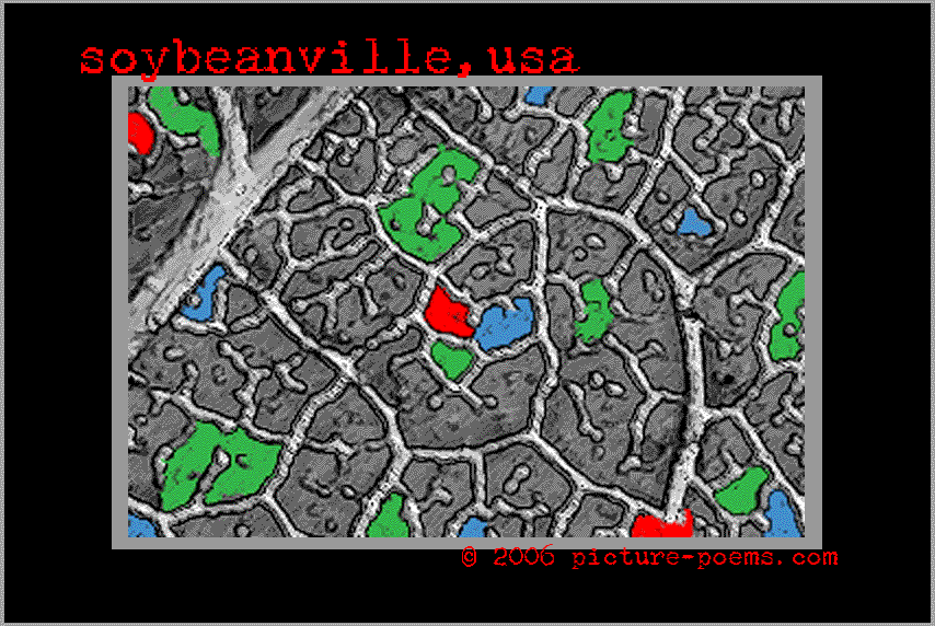
Hypothetical Map of Soybeanville—based on the venation patterns
of an actual soybean leaf (scale: centimeter = kilometer) . . .
Hypothetical Map of Soybeanville—based on the venation patterns
of an actual soybean leaf (scale: centimeter = kilometer) . . .
blue = dug ponds and lakes
green = planted forest and prairie preserves
red = new village centers
gray = organic agricultural (soybeans, etc.) fields
To view / purchase different sized prints of this
image at the
PhotoWeek Store click
here.
[http://www.shutterfly.com/pro/cliffcards/photoweek]
 |
Moon Rise, all-but-full |
 |
Cow Vetch |
 |
Iris on a Wire |
 |
Samara Duo, Red Maple |
| back to Picture/Poems: Central
Display | go to
P/P Photoweek: Archive
|
|
Map
|
TOC:
I-IV |
TOC:
V-VIII |
Image Index
|
Index
| Text Only
| Download
Page |
Newsletter
|
About
P/P |
About Cliff
Crego |
Photograph by Cliff Crego © 2006 picture-poems.com
(created:
VI.11.2005)